
Church Farm.
There has been farmland on the south east of the village for hundreds of years, accessed via Hen Platt to the nearest part called The Lawn. The house on the high street most closely associated with it has had various owners and currently (2016) is called "The Old Dairy" l Listed Grade II. Many people will remember it as Lloyds Pharmacy, before that as Axe's Hardware Store and in the 1950s as Dennison's General Store and Tobacconist. In the late 19th and early part of the 20th century it was Church Farm Dairy run by the Curtis family. In the early 19th century it was a bakery. Today the name Church Farm refers to that part of its land that was taken over by the District Council before WW2. Since 1968 the land has been used as a site for old people's homes. In 2008 the apartment block called Church Farm House was redeveloped.
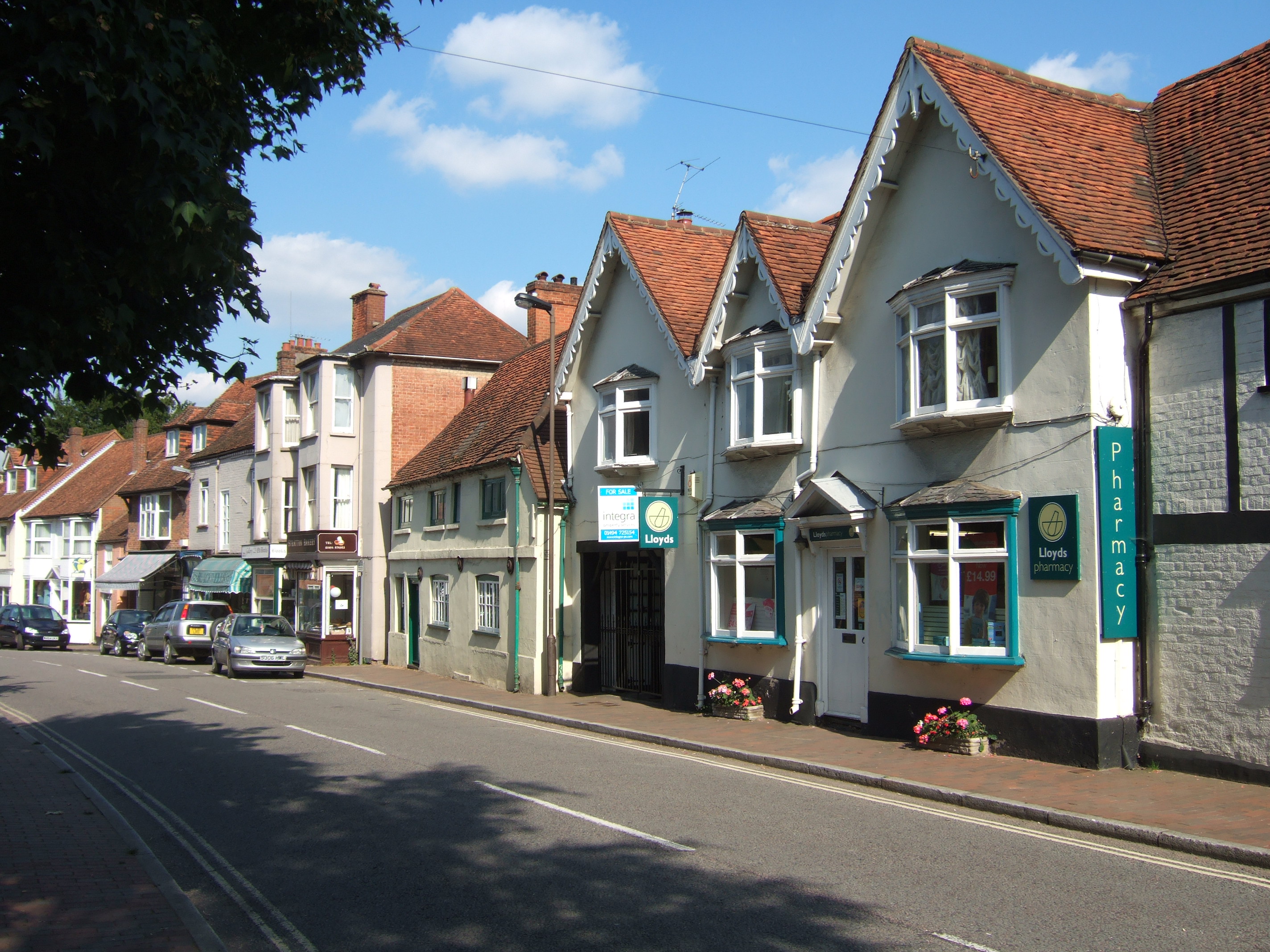
This building on the High St, photographed in 2007, was the shop and the entrance to the farm and buildings behind. It is a late 19th century re-front to a 17th century timber framed building behind. On its left and adjoining is Pilgrim's Rest, a 16th century building refronted in the 18th century. Beyond that is the entrance to the alleyway known as Hen Platt.
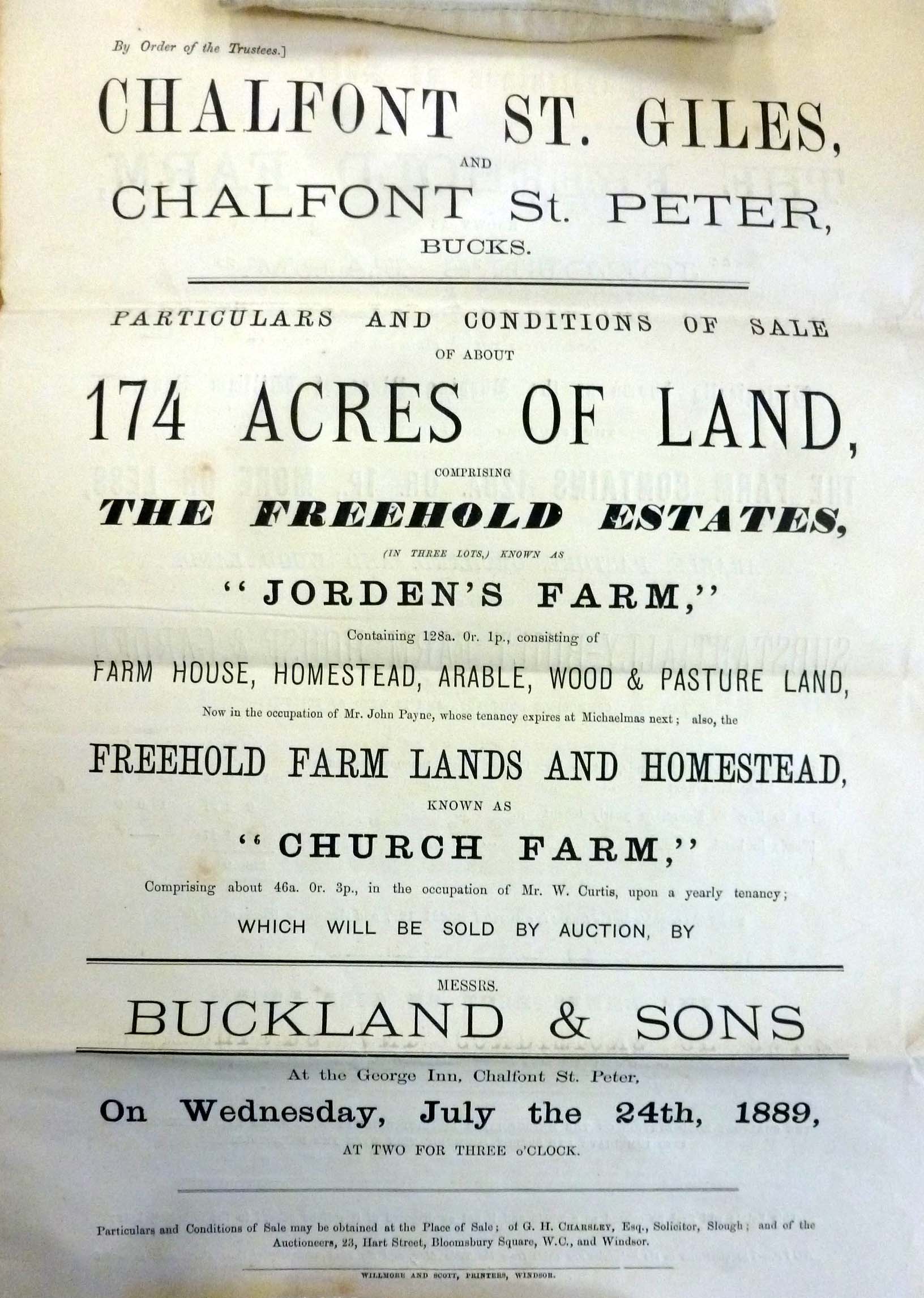
The name Church Farm appears first in the Chalfont St Giles Parish valuation of 1864 (DC 9/14/?) as a manuscript annotation but it does not appear in a published form until 1889 when it and Jordans Farm were offered for sale by auction. They had been outlying parts of the estate of Rev Edward Moore who owned Chalfont St Peter Manor.
The land associated with the house has varied widely in extent over the years and can be traced back to the time it was all part of the Vache Manor when all the land of T the Vache was defined in the Marriage Settlement of James Clayton to Mary Alston in 1684. (CBS BAS 39/43.) There is an isolated reference to a "barn at Chalfont St Giles town side" as early as 1715 in a Deed relating to the sale of Daniel Warley's lands. (D/RA/3/51).This also describes the lands which were previously part of the Vache estate when sold in 1696 to Daniel Wharley.
However to get our bearings better let us look some time later and see the building and land we are discussing on the Tithe Award and map of 1840. An enlarged part of the map is shown below. 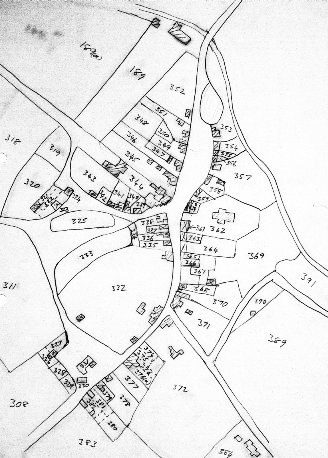
Looking at this tithe map of the village centre we see two plots of land 369 and 370 and the building associated with piece 370, all of which are owned by William Birch and occupied by John Birch. The building we know as Church Farm is on plot 370. William Birch owns and occupies the tenement at plot 366. This today is probably the small building between Commerce House and Warner's. From his Will we know he is a draper and collarmaker. He also owns 368 which is occupied by William Clark who appears to be a cordwainer. Today it is Primrose Cottage.
William Birch had been around for a little while and was quite significant in the village. On the Posse Comitatus in 1798 he is described as a draper. He signed the returns for the land tax in 1810. He owned sufficient property to be included in the list of electors for 1832. Whilst still clearly alive in 1840 at the time of the Tithe Apportionment, he must have died before the 1841 census. His will, which he made in 1831 survives (at CBS F&H AR 70/97 box 3). His son John inherited the property in which John had his baker's shop and the associated garden and orchard. Other property, including the draper and collar maker shop in which William lived plus five other cottages were left to his daughter Elizabeth and husband Mark Brister.
Bowstridge Farm came up for sale in June 1846 and John bought some of the land including meadow land along the river, arable land including Great Town Field (now the surgery and a housing estate) and land in Out Field. In total he bought about 35 acres.
John in turn died in 1849 leaving a Will, proven at the PCC 2 March 1849, showing that he had investments and property to go along with his bakery business and which was left primarily to his son, another John and also a baker. Unfortunately this John also died only a year later, unmarried and with no apparent brothers or sisters. His Will, proven at the PCC 10 February 1850, left all his personal property and money to his mother who was still alive but his real property was to be sold and the proceeds distributed to various aunts, uncles and nieces.
Most if not all of his property must have been bought from John Birch's trustees by Rev.Edward Moore who owned the Manor of Chalfont St Peter and at this time was living at Stone Dean and expanding his estate. On the 13 Sept. 1864 property valuation list for Chalfont St Giles (Q/valuation/?2) Moore is shown as owning Church Farm and The Lawn but it is shown as occupied by a George Robertson about whom we know nothing. The extent was given as 39a 3r 12p. There is also a supplementary list where the occupier is changed to Robert Robertson and the extent reduced slightly to 39a 2r 2p. This reduced extent is because in September 1865 Rev Edward Moore sold 1r 10p of The Lawn to the Churchwardens to extend the churchyard. (Oxford Diocese Records DIOC/1C/5/1377.) Why George Robertson became Robert Robinson we do not know.
Curiously a few years earlier on the 1861 census the house of Church Farm is occupied by James Stacey and his family. He is said to be 32, born in Hyde Heath and is a baker.
On 1 December 1880 a William Curtis (described as a baker and cowkeeper) took an indefinite lease of Church Farm (not detailed but said to be comprising by estimation 84 acres) from Rev E Moore via his agent James Gurney. The lease to be terminated by giving one year's notice to quit the following Michaelmas. (AR 69/94 box 13.)
On 24 July 1889 Church Farm comprising 46a 0r 3p was put up for sale by C E Moore by auction and bought by William Curtis. Moore also sold Jordens Farm at the same sale. (AR 69/94 box 12).
However William Curtis retained the lease he had from Moore on Stone Meadows and also leased additional land from Hill House. By 1902, at the valuation in that year, he had built up a sizeable farm which he essentially retained until his death in 1919. His executors kept the farm and dairy running until 1929.
Fred Kirby, dairyman, was operating there in 1931 (Kelly's Directory).
According to the "Amersham and Chesham Directory" of 1952 it was then occupied by K E Dennison as a General Stores and Tobacconist.
In 1955 A J Axe and Sons moved in as a Hardware Store. This company had been operating out of premises at 27 Kings Road as building contractors since 1899. The hardware shop was closed down in 1983. (Bucks Advertiser 3 Sept. 1983)
The whole property was then redeveloped in 1986 into a courtyard with two residences but retaining a shop. This later was taken over by Lloyds Pharmacy. The photo at the head of this page was taken in 2007 when it was in this state. Finally in 2013 the shop was converted to a private residence.
As far as the land is concerned Amersham Rural District Council appear to have acquired ownership of the Lawn and Hen Platt before WW2 but the details have not been established. (References to covenants in other properties.) In 1968 the land was used as a site for old people's homes. In 2008 the apartment block called Church Farm House was redeveloped.
-----------------
The two pieces of land are very interesting. 369 has historically been called the Lawne and 370 Hen Platt (or Hemp Plott or some combination of these).
They can be traced back to 1696 when James Clayton of the Vache sold off a large part of the Vache estate including these two pieces to Daniel Wharley (D/RA/2/3-4).
In 1715 Wharley sold these as part of all his estate to the first Duke of Portland.(D/RA/1/212 and D/RA/1/217.) The Duke lived at Bulstrode and was extending his estate in all directions.
In 1735 the second Duke of Portland had a narrative survey carried out of his estate. (D/RA/3/51.) It contains the following statement.
"The Barn and Lands in possession of John Grimsdale when sold by Mr Wharley consisting of; a Barn at Chalfont Town Side; The Hemp Platt adjoining to Barn 0.1.5; a piece of Meadow adjoining South on the churchyard called ye Lawn 1.2.0; two fields of arable called Town Fields 24.0.0; a field called Bottom Close 6.0.0; a field called Upper Brambles 5.0.0; a field called Lower Brambles in 11.0.0; High Field or Heathfield 12.0.0; two pieces of arable land lying in a common field called Nowt field and containing each half an acre 1.0.0; two pieces of Meadow in Old Mead 2.1.0; one piece of Meadow in Smalden Mead 1.2.0; one piece of Meadow below Bottom Close 0.2.0. Totalling together 65 acres 0 Rod 5 Pole.
Memo that at Michaelmas 1740 John Grimsdale was tenant to this barn and lands at a yearly rent of £29 being held at will. Since let to him for 21 years from Michaelmas 1741 at £32 per year."
A further survey was carried out by the third Duke in 1775 (D/RA/3/53). It states that the Executors of John Grimsdale holds 67 acres of land.
However in 1790 the 3rd Duke sold his property in Chalfont St Giles.
Conveyance of freehold property in Buckinghamshire by the 3rd Duke of Portland; 15 May 1790 to John Grimsdale of Borntrige (transcription error for Bowstridge) of Great High Field and other closes of land as specified all in CStG. Consideration £1800. (Thus about 65acres on pro rata with other lands sold.) (The University of Nottingham Library, Manuscripts and Special Collections. Portland (London) Collection: Ref:15 May 1790 P1 E2/3/1/14 ).
Grimsdale rapidly sold part of this land to Robert Charsley on 22/23 May 1790 who erected five tenements on Hen Platt and others elsewhere before he died in 1813 (Will NRA PROB 11/1543/195.) His son,also Robert, sold this land to Rev. William Jones of the Stone on 15/11/1816. (AR 69/94 Box 2 Bundle 22.) He had inherited the Manor of Chalfont St Peter and its lands in Dec. 1808 and so the land became part of that estate. His daughter Mary married Rev C E Moore and inherited the estate which subsequently became known as the Moore Estate.
------------------------------------------ May 2017
REFERENCES. Unless otherwise specified, all references given above refer to catalogue references at the Centre for Buckinghamshire Studies at Aylesbury. (County Record Office)
This print is a section of the Chalfont History website.
Please come back soon.
John Dodd ©2015 www.chalfonthistory.co.uk